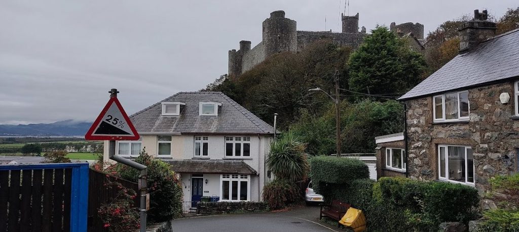
Our home for the week is a holiday cottage on the second hairpin of Twitl, Harlech, in Gwynedd. The dark stone castle looms over this tiny white walled semi-detached house: the lounge of which offers unbeatable views of tourists struggling to tow caravans up and down these 20 and 25% gradients.
I love the way British hairpin bends always seem more steep than the sections of road they connect, which gives cyclists the choice of a sheer inside-line, or a more forgiving but longer route on the opposite side of the road. I was struggling to walk, due to ongoing biomechanical foot-pain, but riding the titchy gears of my hardtail mountain bike was always going to be easier than walking anyway.
We were not staying on the famous climb, we were not staying on Ffordd Pen Llech; “the world’s steepest street”. Although it is a one way street (downhill) for motorists, there is nothing wrong with cycling up this narrow tarmac wall, so I did. Non-cycling friends have told me it would be more fun to cycle down, but they are unfamiliar with the joy of uphill. It takes the fastest cyclists about one minute to cycle these 330m of road… I winched myself up in three and a half.
One thing worth remembering about uphill, is that the top of the hill is very rarely the actual top of the hill. Ffordd Pen Llech climbs 54m and meets a crossroads with the B4573, but the hill continues on Pen Dref rising another 150m to the crossroads with Ffonllech Hir and another 50m climbing after that. The views are stunning – on a sunny day.
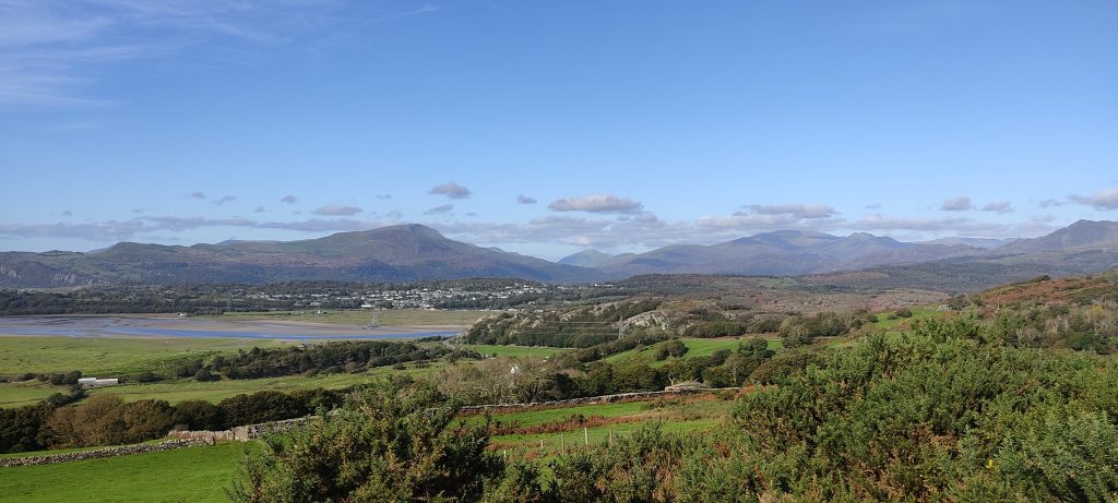
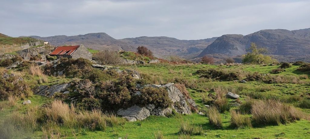
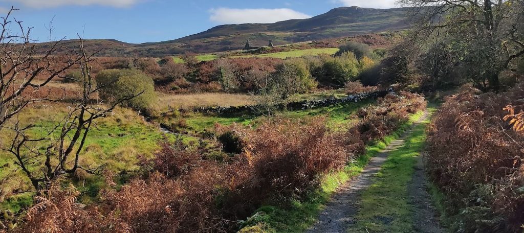
Riding around the lanes behind Harlech was like travelling to another world, where motorcars don’t exist but narrow roads weave through mossy woodland and alongside hidden lakes and reservoirs. There feels to be about 200 square miles of emptiness behind Harlech, between the A496 coast road that runs from Barmouth to Maentwrog, and the A470 which runs inland down to Dolgellau. When I initially planned a few bicycles rides, it appeared that I would only have one 75km circular route to choose from, that was until I discovered the multiple dead end lanes climbing into the hills of Gwynedd. So I spent a few days exploring the hills south of Harlech to the Rhaeadr Nantcol Waterfalls, and north of Harlech to Saint Tecwyn’s Church, including the reservoir behind the church.
I love watching movies that haven’t been spoiled by previews: I love the unexpected storylines and the delight of a movie that has come as a surprise. The same goes for cycling: I love exploring. I love the feeling of finding a delightful dale, a gorgeous gorge, and a wonder-filled waterfall. Meandering through upland meadows on lanes known only to locals, all of which yield semi-secret views: scenes that are free to those who know, but hidden from those who never stray from the main road. Dean Clementson, Jonathon Snowden and Jack Thurston are the cyclists who’ve inspired me to continue when the road runs out.
On one ride: taking an easterly turning off Ffonllech Hir where the road sign warns motorists not to blindly follow their internet enabled cars, I was treated to hairpin after hairpin of narrow empty lane created by seemingly drunken tour guides and rolling downhill to Coed Dolwreiddiog.

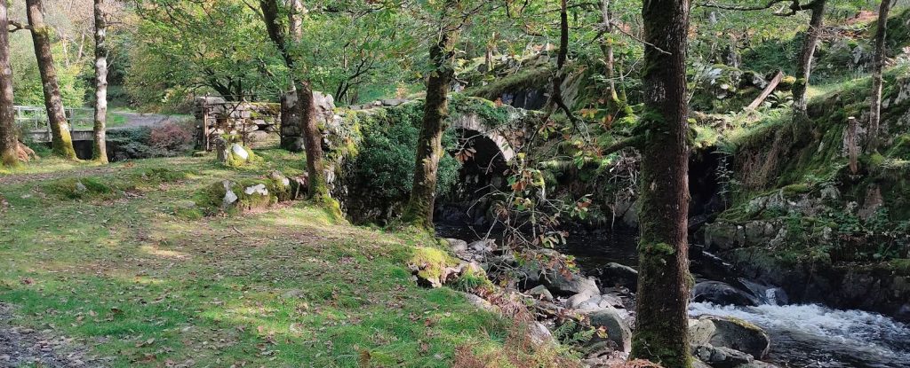
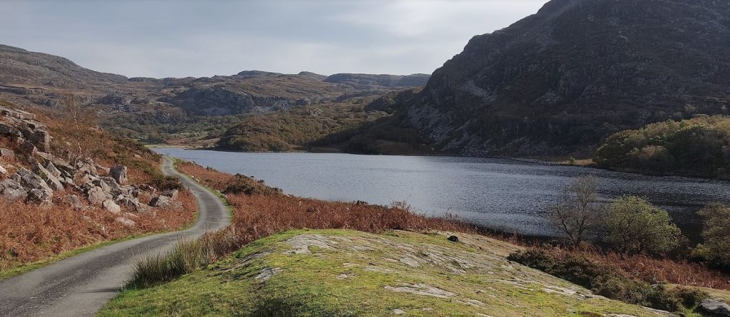
The surrounding hills feel to have almost cupped the valley in their hands, holding them gently so as not to spill water from Liyn Cwm Bychan. I followed the undulations of the road as far as the £5 campsite at the head of the lake. The sun was warm on my back, and the wind light in my face. This was idyllic bicycling.
Another day out involved multiple dead end climbs into the hills behind Talsarnau and Soar. Not many riders like to cycle dead ends, especially when they climb at 10-20% for a mile and you know that you’ll be on the brakes all the way back down. The VeloViewer Explorer game can’t be played without taking these dead ends on a fairly regular basis. I got to wondering about the spirituality of dead ends. Does anyone like retracing their route? Doesn’t it come with a sense of failure to have to go back the way you came, as though you’d gone wrong and sheepishly hope no one who saw you going one way will see you coming back the other way. Do we try to pretend we came over the top of that hill in the distance? Is there a humility to admit that you’ve made a mistake and need to come back and find a new way… but what if you were, like me, exploring to the very end of the road? Mountain climbers must have overcome the self-conscious sense of the judgement of others. Imagine if every return journey from a mountain top involved having to explain why you hadn’t kept going.
“Yes, we reached the top, it was a dead end and we’re coming back now. No, we didn’t go the wrong way, we were going to the top. That’s right, it is a dead end, and now we’re coming back.”
Climbers explaining why they’re coming back down the mountain
Deliberately exploring to the end of the road takes courage, I think. To cover this ground knowing that you have to come back but to not give up. To acknowledge to yourself that it would be easier to turn round now, because you’ll be back this way soon. Turn round now and save yourself the climbing, save yourself the time… there’s nothing to lose?
And yet there is so much to lose by turning around early. The view from the top of the hill is so much better than the view from the bottom of the hill. The way that hidden valleys can only be seen from the top of dead end roads, and that every turn and every pedal stroke does take you somewhere new, somewhere previously undiscovered. It takes courage, and a dogmatic determination to get the VeloViewer tile that can only be found by coming this way. I think there is a spiritual strength to continuing towards an ending; from dust we came and to dust we will return. However, cycling gives us the chance to see the view from both directions.
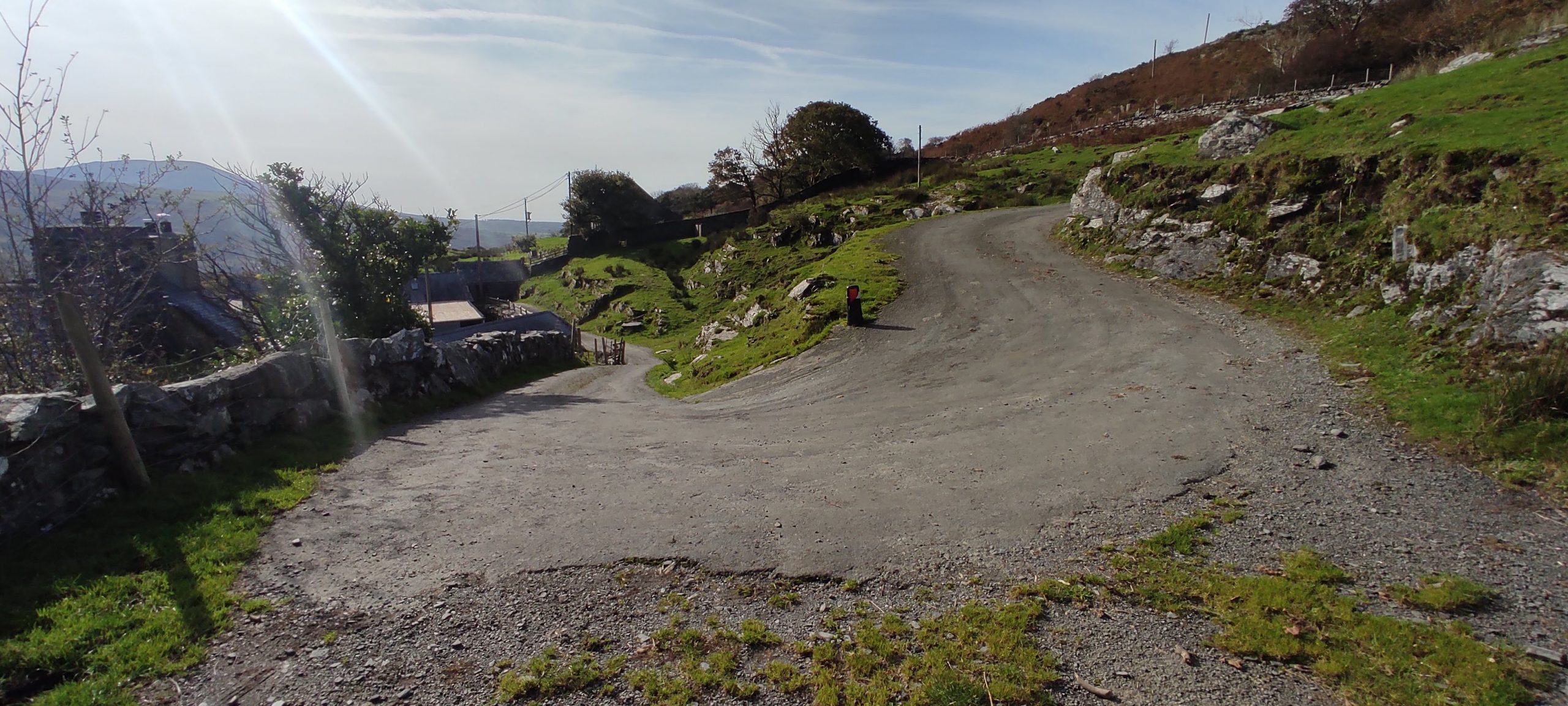
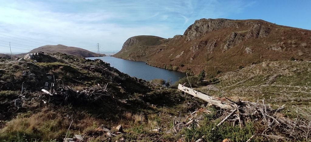
Most of my cycling was on tarmac, or tarmac with a strip of grass down the middle. Towards the end of my Harlech holiday I found some roads that were unpaved. Gravel, stone, and mud. In an effort to shortcut the route between two VeloViewer tiles, I wanted to take advantage of some bridleways. These ones found me heading into part demolished woodland, which seemed to have suffered an attack from the Orcs of Isengard: pine trees stripped of bark, like the fingers of mountain trolls cut to the bare bone, petrified and pointing at the sky. A reservoir appeared, with the narrowest of outlets; a mere crack between hillsides through which the Irish sea waved at me. My route was scored into the side of the hill in the distance, a pencil thin line slowly carving across and down to the water. I had assumed bridleway, but discovered the heaven of MTB routes: single-track, a strip of gravel no wider than my 2.2″ 29er tyres. To my right, a cliff wall stretching to the sky. To my left, treacherous ferns disguising a lack of foothold and the associated plummet to the water’s edge. This section required balance and complete commitment: ride.
I’ve never really embraced mountain biking, I prefer the slow burn joy of an adventure unfurling as I explore, instead of the adrenaline filled rush associated with “yay, I’m not dead”. Despite this, I was glad to be alive and thrilled that I’d ridden such an inaccessible route. I wanted to tell everyone what I’d done… but the woman walking her dog the towards me as I cycled the broad bridleway towards Saint Tecwyn’s Church beat me to it by saying, “Just going for a swim in that wonderful lake you’ve passed.”
May I commend the roads, hills, valleys and dead ends of Gwynedd to you. If you take a fistful of low gears, you might really enjoy the hairpins of Harlech.